



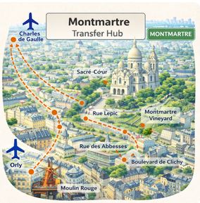

Private transfer to the Montmartre district from Paris airports. Montmartre is one of the most distinctive and visually unique arrival zones in Paris. Perched on a hill in the 18th arrondissement, it offers a completely different urban experience compared to central flat districts. This elevated position, combined with its artistic identity and village-like atmosphere, makes it a highly attractive destination for travellers seeking authenticity.
Whether your accommodation is located near the Sacré-Cœur, along Rue Lepic, or in a quieter residential street around Abbesses, organizing your CDG airport transfer in advance is essential. The district’s topography and street layout create specific access conditions that differ significantly from other Paris areas.
After landing, many travellers look for a Paris airport transport solution that avoids unnecessary complexity. Public transport can bring you close to Montmartre, but the final segment often involves uphill walking, stairways or navigating narrow streets. This can quickly become challenging with luggage or after a long flight.
Understanding the structure of Montmartre is key. The district is not only elevated, but also divided into multiple micro-zones with different access levels. This makes direct transfers particularly valuable for ensuring a smooth and efficient arrival.
Quick comparison of transport options from CDG to Montmartre
| Option | Price | Time | Best for |
|---|---|---|---|
| 🚆 Train (RER + metro) | €11–12 | 60–80 min | Budget travel |
| 🚖 Taxi | €50–65 | 35–50 min | Direct ride |
| 🚐 Private transfer | €70–120 | 40–55 min | Comfort & luggage |
Why Montmartre is a top airport destination
Montmartre stands apart from other Paris districts due to its elevated terrain and artistic heritage. The hilltop location provides panoramic views and a distinct atmosphere, attracting travellers looking for a more intimate and authentic Paris experience.
However, this uniqueness also creates logistical challenges. Streets can be steep, narrow and sometimes inaccessible to certain vehicles. Areas near the Sacré-Cœur or Place du Tertre may involve restricted access or require drop-off points slightly below the final destination.
To better understand the cultural and geographic richness of this district, travellers can explore our
complete guide to artistic landmarks and cultural sites in Montmartre
.
Public transport options exist, but they rarely provide direct access to upper Montmartre. Stations such as Anvers or Abbesses still require uphill walking or stairways. This is why many travellers choose a direct Paris airport transport solution adapted to the district’s specific constraints.
Key landmarks and streets included in this transfer zone
This transfer zone includes major landmarks, streets and access points that define Montmartre’s geography.
- Sacré-Cœur Basilica
- Place du Tertre
- Rue Lepic and hillside streets
- Abbesses district
- Boulevard de Clichy access zone
- Montmartre vineyard area
- Espace Dalí Museum
For detailed routing and local access points, travellers can refer to our
complete guide to streets and transfer access points in Montmartre
.
Nearby transfer areas and connections
Montmartre is connected to several key Paris areas, although its elevated position creates a clear geographical separation from central districts.
Opéra area |
Louvre & Palais Royal area |
Notre-Dame area
Choosing the correct transfer zone is important, especially when your accommodation is located between lower Montmartre and surrounding districts.
Airport routes and travel time to Montmartre
Travel time from Charles de Gaulle Airport typically ranges between 40 and 75 minutes. The final segment of the journey may vary depending on elevation and street accessibility.
- Private transfer: adapted routing for hillside access
- Taxi: flexible but subject to traffic
- Train and metro: economical but requires elevation changes
- Ride-hailing: flexible but dependent on availability
Best for: artistic stays, boutique hotels, hillside accommodations, unique experiences
Transfers available from all Paris airports
Transfers to the Montmartre district are available from all Paris airports, with varying travel conditions.
- Charles de Gaulle Airport (CDG): main international hub
- Orly Airport (ORY): alternative route from the south
- Beauvais Airport (BVA): longer journey requiring planning
Choosing the right Paris airport transport solution helps ensure a smoother arrival despite the district’s specific constraints.
Best option depending on your travel profile
- 🧳 With luggage → private transfer
- 👨👩👧 Family → van transfer
- 💸 Budget → train
- ⏱️ Fastest → taxi
- 🌙 Late arrival → private transfer
This structured approach helps travellers select the most appropriate option based on their needs.
Plan your arrival with confidence
Arriving in Montmartre requires more planning than in most Paris districts due to its elevation and unique street layout. Choosing a reliable CDG airport transfer ensures a smooth and efficient arrival adapted to these conditions.
With a well-organized Paris airport transport solution, you can reach your destination comfortably and fully enjoy one of the most iconic and character-filled neighborhoods in Paris.
All transfer routes include direct options from CDG, Orly and Beauvais airports with full destination coverage.